
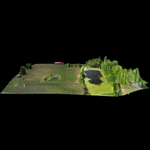
Modern farming and ranching requires innovative solutions, and drone technology is revolutionizing agriculture. At Have Drone Will Travel, we provide cutting-edge agricultural drone services in Kansas City and surrounding areas. From general agricultural land mapping and mapping to crop damage assessment, our farm and ranch drone services offer efficiency, accuracy, and cost savings for farmers and agricultural businesses.
Drones are transforming the agricultural industry by providing farmers and ranchers with detailed data for improved decision-making. With drone services such as land mapping, drainage pattern mapping, and crop scouting, we help streamline your operations and enhance productivity. Our agricultural drone services allow for precise monitoring, optimizing your resources and reducing costs.
Choosing Have Drone Will Travel means you’re working with experienced professionals who understand the unique aerial photography and videography needs of modern farmers. Our drone services enhance agriculture management by:
With our team of experts and state-of-the-art drone technology, we deliver superior agricultural drone services designed to maximize your efficiency and profitability.
From mapping to crop damage assessment, our drone solutions cater to various agricultural needs. Explore our specialized services below:
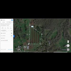
Topographical maps provide valuable insights into terrain variations, helping farmers plan their fields effectively. With topographical drone mapping, we deliver high-resolution imagery for soil analysis, elevation studies, and irrigation planning, allowing for improved land management and crop placement.
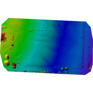
Proper drainage is critical for healthy crops and soil management. Our drone-based drainage pattern mapping services help identify areas prone to water accumulation and erosion. With precise data, farmers can implement targeted drainage solutions, enhancing soil health and crop yields.
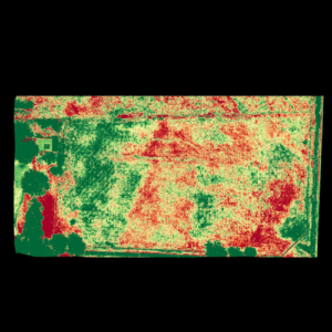
Stand count assessments are essential for understanding germination rates and plant health. Using drones for crop scouting allows farmers to efficiently monitor crop conditions, detect early signs of disease, and optimize fertilization schedules, leading to higher productivity and reduced losses.
When disasters strike, assessing crop damage quickly is crucial. Our drones provide accurate acreage calculations for insurance claims, allowing farmers to document losses with precision. Whether due to storms, pests, or disease, our crop damage assessment services offer reliable data for insurance and recovery planning.
Managing livestock is easier with drone technology. Our services include monitoring fences and pens for damage, assessing resources such as water and grazing areas, and surveying livestock after severe weather. Drones provide a cost-effective way to oversee large areas, improving operational efficiency and animal welfare.
Ready to integrate drone technology into your agricultural operations? Contact Have Drone Will Travel today for a free consultation or a free quote. Our team is here to help you optimize efficiency, reduce costs, and take your agriculture business to the next level with our precision drone services.


Ready to integrate drone technology into your agricultural operations? Contact Have Drone Will Travel today for a free consultation or a free quote. Our team is here to help you optimize efficiency, reduce costs, and take your agriculture business to the next level with our precision drone services.
Copyright © 2025 Have Drone Will Travel. All rights reserved.