Get to Know Have Drone Will Travel
About Have Drone Will Travel
Our Company
- Veteran Owned
- FAA Licensed and experienced small Unmanned Aircraft Systems (sUAS) Pilot
- Fully Insured
- Based in Jackson County Missouri and serving Western Missouri and Eastern Kansas.
Our Equipment
- Cutting edge aircraft by DJI
- Photogrammetric software through DroneDeploy
Why Us?
We bring a technical approach to drone photography using advanced drones and cutting edge software to create and compile images into ultra-high resolution mapping with a high degree of relative accuracy.
Drone photography is all we do. Other companies may have drone photography as an add on, but we fly drones full time.


Frequently Asked Questions
Please reach out to us at : weshamerly@have-drone.com if you cannot find an answer to your question.
Photogrammetry refers to the process of obtaining measurable or reliable information about physical objects through photography. In this case we are referring to aerial photogrammetry, where the photographs are obtained through the use of a drone taking numerous pictures of an object, area, or terrain and “stitching” them together into a two or three-dimensional ultra-high-resolution image called an orthomosaic map, or simply an orthomosaic.
A standard aerial photograph has a number of problems. First, it is expensive; second, it is taken from a distance and lacks high resolution; third, it is taken from a single viewpoint creating a distorted image in which the sides of buildings are seen in one direction, and not in another; fourth, due to the angles, the photograph does not have accuracy which is required to make measurement of the area photographed; lastly, since the aerial photos will be taken at different altitudes and locations. The final product cannot be overlapped to easily identify changes and the progress of the project.
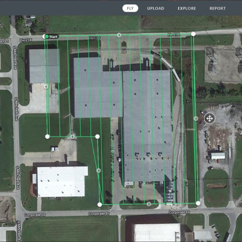
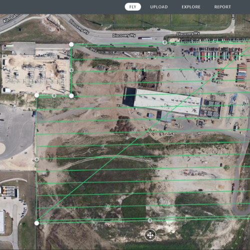
An orthomosaic uses a pre-programmed flight plan to fly the drone at a relatively low altitude (100-400 feet depending on obstacles and desired resolution) to take a multitude of high-resolution overlapping photographs while recording accurate spatial coordinates and distances with each picture. The pictures are then processed or “stitched together” to create the final orthomosaic.
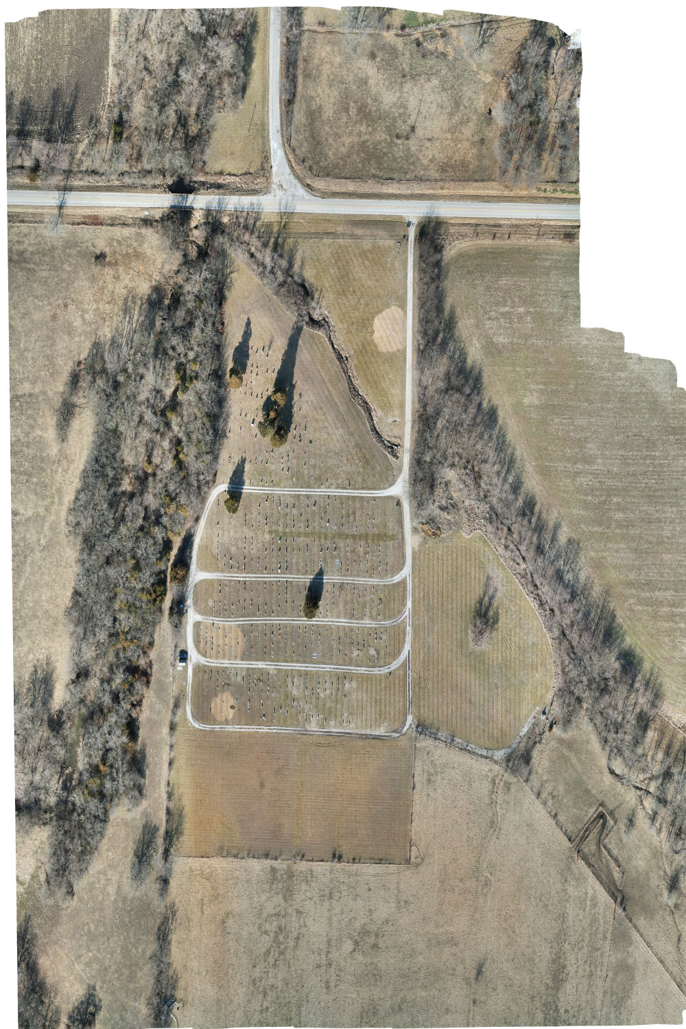
The final map creates an accurate top-down view of the area without the distortion created by aerial photographs. They display a high degree of relative accuracy enabling the user to make accurate measurements between objects on the map. Because they are created from other high-resolution photographs, the final product can be expanded to a very high resolution: around .5 to 1 inch per pixel. Notations can be made within the project to denote points on interest, and while inspecting an area on the final map the user can link to the original photograph for comment or analysis.
When using the map in 3D mode, the software creates an accurate 3D image of a building or object. It can be used to analyze stockpiles of material on hand, or to estimate the amount of cut or fill necessary for earthworks for the project. It can also indicate areas of drainage or sloping of the terrain.
Orthomosaics created on a regular basis can assist in tracking the progress of your project and compare the planned build with the as-built and final product.
Most orthomosaics are created with a high degree of relative accuracy due to the GPS tracking contained in the drone itself and stored in the metadata of each photograph. In simple terms this means that the objects depicted in the final map are accurate, and measurable, relative to each other in the photograph.
Due to the variation in GPS signals, there will be slight differences over time in the accuracy of the map in comparison to the Earth itself. This is corrected by the use of ground control points (GCPs). The GCPs are points visible to the drone (usually painted in specific locations or markers of some type) placed by surveyors to increase the accuracy of the map. The software recognizes the GCPs and the user inputs the exact location marked by the surveyors into the software for each point. The software can then adjust the map location on the Earth creating what is known as absolute accuracy.
There are a number of mapping and flight planning programs out there and each has advantages and disadvantages in their use. We have chosen DroneDeploy as our go-to program for our photogrammetry because of its integrated flight planning, flight control abilities, and processing speeds. Drone Deploy also allows for the client to integrate CAD software and overlay architectural diagrams, as well as make notes and mark on the final product. You can learn more about the program at: https://www.dronedeploy.com/
In some cases, however, other flight planning, flight control, or orthomosaic processing programs, such as WebODM, Maps Made Easy, Dronelink, GeoNadir, or Litchi may be used. Each program may have features more appropriate for a given flight and many will create photographs that can be used by others. For example, a flight may be planned and flown using Dronelink to take advantage of a lower altitude and then processed in Drone Deploy to take advantage of its processing capabilities and client interaction. The same photographs can then be processed a second time through WebODM to take advantage of its local processing and ability to control final pixel sized in the final product.
Unfortunately, at this time, we are limited by our equipment to visible spectrum photography only. Depending on future demand, we plan to expand into the near-infrared spectrum in the future.
We are based in Jackson County Missouri and serve Western Missouri and eastern Kansas. Locations outside of the local area are possible but may require some extra time to obtain the licenses needed to operate in those venues. Luckily this process is mostly automated, and the legal requirements can be satisfied in a timely manner.
The baseline package for real estate will contain unedited photos (both in jpeg and RAW with exposure bracketing) and unedited video. More advanced packages include photos processed using Adobe Photoshop and Lightroom and videos created in Adobe Premiere. The highest include multiple site visits in order to obtain different light levels, evening lighting, sunsets, etc.
I travel quite a bit and take a drone when possible. Traveling for a contract, although possible, would be fairly expensive to the customer as it would include travel, per-diem, lodging, licensing, etc. For very large projects, however, this may still be an affordable option.
No. We do not photograph weddings. There are already a large number of very talented wedding photographers in the area who are capable of taking the specific shots needed for a wedding. Some include drone photography as part of their packages.